Satellite Images Used to Track Food Insecurity in South Sudan
Tuesday 6th June 2017
The world is watching closely as food shortages grip parts of Africa and the Middle East. As humanitarian groups respond to the crisis, they have to solve a major problem: how to track food security in areas that are simply too remote or too dangerous to access.
The Famine Early Warning Systems Network (FEWSNET) has come up with an innovative answer. The U.S.-funded organization is working with DigitalGlobe, a Colorado satellite company, to crowdsource analysis of satellite imagery of South Sudan.
The effort will rely on thousands of volunteers — normal people with no subject matter expertise — to scour satellite images looking for things like livestock herds, temporary dwellings and permanent dwellings. The group has selected an area of 18,000 square kilometers across five counties in South Sudan to analyze.
Read more from Voice of America here.
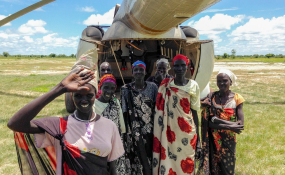
South Sudanese refugees wait outside a helicopter. Photo/VOA


.jpg)
.jpg)